
When people think of winter skiing and snowshoeing on Vancouver Island, Mount Washington Alpine Resort frequently comes to mind. While the resort is very popular and has plenty to offer the winter enthusiast, there is a nearby alternative for those interested in a more remote yet fairly easy to access backcountry experience.
A relatively unknown hidden gem called Mt. Becher lies about 12km SE of Mt. Washington. It falls within the extreme western edge of a small offshoot of Strathcona Provincial Park and features plenty of snow, skiable terrain and grand 360 degree vistas of Strathcona peaks, the Comox Glacier and the mainland coastal mountains.The route to the top of Mt. Becher is about 6km (one way) with an elevation gain of 600m. Except for some steeper sections (which get your heart pumping) the terrain is pretty easy to travel. There are no sharp drop offs or rock scrambling required on the main route up (but if you want you can find these off to the sides of the trail if you walk a short ways). Depending on your fitness level, trail conditions, weight of your pack and how distracted you get taking photos of the marvellous scenery, travel time to the top ranges from 2 to 4 hours and about 1.5-2 hours back down. The route is fairly popular but if you are one of the first up after a snowfall and have to break trail be prepared to spend more time on the ascent.
The trailhead is located at the parking lot of the old Forbidden Ski hill. From there head straight up the hill following the old ski lift. This part of the route has some of the steeper sections you will encounter on the trail.
Once you get to the top of the old ski hill the walking is easier as you traverse a gently up sloping plateau through majestic trees.As you gain altitude you start to encounter views of Mt. Becher.
Continuing up the trail brings you to a very spectacular bowl housing Boston Falls and Boston Lake. Local ice climbers use Boston Falls so there is a trail down to the lake. There is a very good viewpoint here so spend some time and enjoy the view.
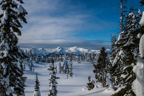
Past Boston Lake the trail becomes steeper again as you approach the summit.
The final approach to the summit is largely open with scattered clumps of trees.If the conditions are right the trees may be covered in wind-swept snow making the whole area a winter wonderland.
The summit itself is dome shaped without a clearly defined top. Walk around the summit and take advantage of the views.
To the North-East you will see Georgia Strait (Salish Sea) and the Coastal Mountains.To the South-East is Comox Lake.
To the South-West is the Comox Glacier and other spectacular peaks in Strathcona Park.
To the North-West you should be able to see the ski runs on Mt. Washington.
The route is popular with both snowshoers and skiers (and hikers in the warmer months). Some of the steeper sections can be a little tricky on skis so consider your level of expertise before heading up. The summit sections and the old ski hill sections are favored by the skiers to get some turns in. In the early part of the season when the snow pack is low the old ski hill sections can be challenging due to the growth of Alder trees on the old runs but with enough snow these become covered.
Getting There
Travel North on Highway 19 (Island Highway) from Nanaimo until you pass the first exit to Courtenay/Comox (don’t turn into Courtenay, stay on the highway). Turn right at the lights at Piercy Road and after a few hundred meters take another right on Forbidden Plateau Road. Follow this road all the way to where it ends in the parking lot of the old Forbidden Ski Area. Although the road turns into gravel it is very well maintained and passable by any 2wd car. The lower slopes of the old Forbidden Ski hill are very popular with families and they seem to keep the road well cleared in winter.
You can download a GPS track of the route here:
More details on the route up can be found here:
Warnings
Although this location is relatively easy to get to and many families play on the lower slopes of the old ski runs, keep in mind that Mt. Becher is a backcountry location and subject to all the usual perils. Take appropriate precautions by bring the right gear, letting someone know of your planned route and assessing the avalanche danger. Although I have no personal experience, I have heard from others that you can get cell phone coverage from the tower on Mt. Washington. Most of the photos I’ve posted here are of lovely sunny days but it can also be cold, blowing, foggy and offer white-out conditions (see photo below). Check the weather forecast before you go and always be prepared for inclement weather.
Equipment
Suggested equipment will depend on time of year, local conditions and your mode of travel but some common equipment will be useful no mater how you travel. A GPS is a very good thing to carry (with the track available above loaded). In good weather the route up is fairly obvious but if the weather closes in landmarks can disappear making navigation difficult. Hiking poles are useful as there is a lot of up hill travel. I consider a camera as essential but that may just be my bias as a photographer. It’s an excellent idea to carry some sort of communication device as well should you get into trouble (Cell phone, radio, Spot Messenger). Take clothing appropriate to the conditions.
Great photos of Mt. Becher. It’s one of my favorite day hikes in every season. My first time up was in fall and colors were amazing. This past winter I went snowshoeing up the Mt. several times. The views are breath taking at the top. This is a good article. Thanks for posting it Lorne.
[…] touring and tried my hardest to get out as much as I could. One of my favorite places to play was Mount Becher on Vancouver Island. I’ve spent most of my time up there in the snow on either skis or […]