
This hike was definitely a random adventure that turned out to be a lot of fun. We wanted to look for this plane that we had heard was in the area of Radar Hill in Tofino. We weren’t really sure where exactly to go but knew it was somewhere at the end of a trail. (Note: we found our way ok but some don’t. The trails get a bit convoluted so take great care watching where you came from and make sure you remember how to get back.)
Off we go.
We parked at the bottom of Radar Hill and hiked south along the highway for a few hundred metres. Just after one of the big bends about a kilometre away from the parking area turn into the bush on a fairly well used trail. It should be good single track. You shouldn’t have to duck through many brambles or branches. If you have, then you’ve turned off too early (or late). The trail is around the telephone pole marked 300 with the airplane drawn on it. (Late 2012 the telephone poles were changed. The trail is 15 poles from the Radar Hill parking lot and has a small airplane drawn on it. Thanks to Soccermom for updating us in the comments.)
Continue on up this single track up a hill and down the other side. You will have to go around an old creep abandoned building to do this. You can go inside if you want, there shouldn’t be anything there. At least there wasn’t anything(one?) in it when we were there!
Heading down the other side you’ll get into some pretty muddy territory. It’s quite low and wet in this area so take good boots. I was in trail runners when we did and had to be extra careful but that kept the trail interesting. A couple people ended up in the mud up to their calves, so pick your footing well.
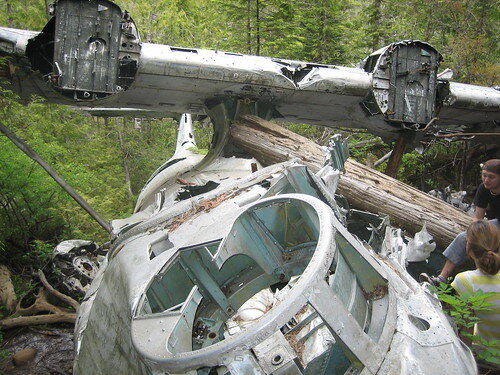
Follow the marked ribbon all the way across the flat marshy area. If you can tell direction we’ll keep heading in the direction of the ocean. You’ll see the land start to slant up before you get to the water in a ridge that runs parallel to the beach. The crash site is on the near side of that ridge. You should come across a couple large pits filled with water that are left from detonating the explosives that were on the plane when it crashed.
[UPDATE]: Please be careful continuing up the hill past the bomber. I wrongly assumed that there would be views of the ocean from the ridge but according to Randy from the comments below that is not the case. There really isn’t much up there and only looks like a trail because of people taking a few steps further every time. Always be careful taking a trail you do not know. If in doubt turn around or go with someone who knows the area. Thanks for the information Randy.
GPS for this trip: Having the gps for the trip was nice but not required. It would definitely help finding the entrance to the trail off the road and the correct trail on the way there. Most of it is marked fairly well.
Gear for this trip
Colorado 300 GPS – nice to have, not required
Salomon Wings Trail Runners – boots would have made it easier, just pick your footing carefully with runners when it’s muddy.
Food and Water – Never head out on a trip without extra food and water. Even if you are just going for the day, you might find yourself overnighting somewhere.
Cell Phone – A communication device is always a good idea to have when going out into the woods. If you get lost you’re going to be very happy you had it.
Extra Links about the trail:
Trailpeak track: http://trailpeak.com/trail-Canso-Crash-Site-near-Tofino-BC-5053
Flickr Images: http://www.flickr.com/photos/rcthink/sets/72157605969155301/
[…] Check out a crashed plane near Tofino. […]
We just did the hike today. It was a beautiful sunny day & great for hiking but the “trail” was really mucky, so I would definitely suggest water proof hiking boots that go to the ankle. It took us about 2 hrs to get to the plane because it was a challenge to get through the muddy bits & we didn’t know where we were going or how far it was. It only took 40 min to get back. A great hike with great reward at the end & good exercise. I say go for it!We want to find the tree house in Ucluelet next……. anyone know where this is?Thanks for your blog, it was helpful for us to do this hike today.
Great to hear you got out there April. Sounds like the conditions we went out there in. A few of our group got a rude surprise when their feet slipped off rocks and into the mud. Their shoes almost didn’t come out!I’m not sure where the tree house is. I’ll see if I can find out for you. Did you go any further than the plane towards the water? Did you get any photos of the trail? I’d love to see them.
Hi Ross,Nice website and photos of adventures. I would ask and suggest something regarding the Canso Bomber material on your page. The information posted regarding the trail beyond the Bomber if misleading as there is no view of the water. Actually the ocean is quite some distance (even though it is very loud at the crash site) and there are more hills between the top of the ridge beyond the plane and the ocean. If you are wondering where the “trail” goes, it doesn’t really go anywhere but into a maze of other side/wildlife trails.Primarily I am writing this because I just returned from a search for 5 people (who followed the advice on your website) and got turned around. Please don’t take this personally as it is not meant that way. Over the last 10 years, there have been our local SAR volunteer group and Parks staff have had to spend many hours in the dark looking for people who have followed that trail and got turned around.I meant to write you last summer to ask you to remove the part refering to ocean views enticing people to go beyond the bomber and afetr speaking with the people tonight I thought I should write now.Thanks.
Thank you for the info Randy, I will update my post right away.
I can see some people losing their shoes along that hike! I thought about taking a couple photos of the trail but I found myself too busy trying to figure out my next move through the mud! It was like a chess game! I took a photo of the sink hole where the bombs were detonated, the tattered building at the start of the trail, & of course, the plane.There was a sign on the hillside by the nose of the plane that said “Dead End” & not to continue further. It was after 3pm & starting to cloud over, so we wanted to get back asap. Getting out was much faster than getting in!Locals told us about these hikes, otherwise we never would have known about them. The next day we went to the blow hole just before Ucluelet. Have you done that one? It’s amazing! I could have sat there all day & watched it! I took some photos & a video of the water spouting up. The hike is short but hard to find if you don’t know about it.We didn’t have time to find the tree house as we had to come back home to bustling Vancouver :0( so next time!I’d be happy to send you some photos when I get organized here. We just got home & my photos are still on the card.
Sounds like a great trip April. I’ll do some digging and see if I can find some Treehouse info for you for next time you come over. I’d love to see your photos.Thanks for the info!
This is on my list of things to do… Next summer! haha
Definitely worth it. Try and go on a dry day so you don’t lose your shoes!
Hi -Congrats on doing something about giving people hiking info. However, if you’re going to tell people about trails like this one, I’d like to really stress (as a Tofino local) that warnings should be put out for hikes like this one.The reason that there is no “offical” info about the bomber trail (even though it is in the National Park) is because so many people end up getting lost out there. Partly because people think they can go from the wreck to the ocean (OK, of course some people can go anywhere – but you need to be a really good navigator to get there AND back again) and also because it is easy to get TO the bomber – but it is harder to get back, with all of the bifurcating trails. Lots of people get ost trying to get back, because they did not realize that they should pay close attention. (The ribbons change all the time – people add them or take them down – so you can’t count on them).So if you’re giving info about “unofficial” trails, I think it’s important to give the warnings too – these trails re not for everyone. Both the bomber trail and the Radar Hill trail keep our Search and Rescue crews busy year-round because of people who, one way or another, weren’t prepared for trails that require mud-slogging and navigation.Anyway, your website looks good. That’s just something I think you should be aware of. Like I said, these trails are not for everyone, and I hate seeing people get in trouble.
Hi Jacqueline. Thanks for the comment!It’s tough to provide good information for hiking and stories from our trips and at the same time make sure people understand the importance of being prepared for the conditions and bringing a gps, knowledgeable person or even a compass to help get back to the car.The trails are definitely a bit confusing but if you keep heading in the same direction you’ll get back to where you started. That said I had a gps with us to fall back on if we needed it. I brought it just to make the gps track and didn’t need to use it to get us unlost.I’ll add it a little warning near the top but, to be honest, I’m not sure how much good it will do. I think there might still be those people that will head out unprepared and lose their way.Thanks again for the comment.
actually its telephone poll 300… I live in Tofino 😉
Hey S, I’ve already got 300 in the article. That’s the right pole isn’t it?
Ross -Great post about a fantastic route.I have a detailed trail description in Tofino Guide (www.tofino-bc.com/shop), which has a few more points, but you’ve pretty much got it covered here as well.I just hiked it to check for changes (I’m updating the guide), and a here’s a few points that I’ve noted if it helps:* There’s now a rope strung along much of the trial to help guide folks. Follow the rope if it’s there!* Gumboots are the best footwear for this hike. It’s not that long — about 2km one way — and so no need for fancy hiking boots that may or may not survive the trip.* Even though Parks Canada doesn’t recognize this as a trail, they would very much like folks to end their walk at the bomber. Echoing Randy’s comment, this is where almost everyone gets lost, necessitating a costly search and rescue.* Avoid taking any of the side trails along the way — they all dead end, are uninteresting and are the other reason folks get lost on this trail.* There is decent cell coverage (depending on your carrier), so bring along your phone for added safety.Jackie and Randy’s comments are bang-on: I can’t stress the importance of route finding on this trail. Also, tell someone you are hiking the trail, when you’ll be back and contact them when you are back safely.Cheers,-John P.www.tofino-bc.com
Thanks for the comment John! It’s a guide in itself! I’ll do some updating on the post to include your new information. Thanks so much for letting me know. I will be getting back out there to check out the trail again soon.
[…] way to the bomber and then head back, it’s really cool! I used the information I found on Pure Outside’s site to get directions to the bomber. Good luck, but remember this trail is not for everyone… be […]
I think they have put new telephone poles in as we found no numbers but it was 15 poles to the south of the radar hill parking lot. The pole had a hand drawn picture of an airplane on it. Great trail, super muddy. It was a great idea by whomever put the rope as a guide.
I think they have put new telephone poles in as we found no numbers but it was 15 poles to the south of the radar hill parking lot. The pole had a hand drawn picture of an airplane on it. Great trail, super muddy. It was a great idea by whomever put the rope as a guide.
@Soccermom Thanks for the update! I remember that mud. Almost lost my shoes in it. Really appreciate you taking the time to update us with the new poles.
What a great experience. The nice thing about the mud, is that it makes it a kind of acrobatic tour to get around it. Balance on trees, hard pieces of grass, holding branches while making a big jump. Reaching the bomber after about 1hr is really nice experience. There’s no way to get lost if you follow the rope, that’s a great help!thanks for all the info!Bert
Thanks for the update Bert! It’s a great hike. I’ll be doing this one again next week. Stoked to get out there again.